The Karakum Desert, also spelled Kara-Kum and Gara Gum is a desert in Central Asia. It occupies about 70 percent, or 350,000 km², of the area of Turkmenistan. Covering much of present day Turkmenistan, the Karakum Desert lies east of the Caspian Sea, with the Aral Sea to the north and the Amu Darya river and the Kyzyl Kum desert to the northeast. In modern times, with the shrinking of the Aral Sea, the extended “Aral Karakum” has appeared on the former seabed, with an estimated area of 15,440 sq. The sands of the Aral Karakum are made up of a salt-marsh consisting of finely-dispersed evaporites and remnants of alkaline mineral deposits, washed into the basin from irrigated fields. The dusts blown on a powerful east-west airstream carry pesticide residues that have been found in the blood of penguins in Antarctica.

9. Great Sandy Desert, Australia
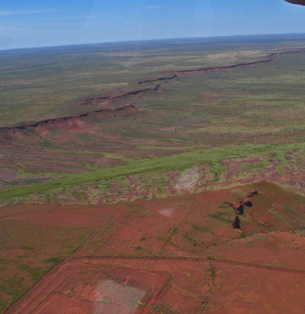
The Great Sandy Desert is a 360,000 km2 (140,000 sq mi) expanse in northwestern Australia. Roughly the same size as Japan, it forms part of a larger desert area known as the Western Desert. The vast region of Western Australia is sparsely populated, without significant settlements. The Great Sandy Desert is a flat area between the rocky ranges of the Pilbara and the Kimberley. To the southeast is the Gibson Desert and to the east is the Tanami Desert. The Rudall River National Park and Lake Dora are located in the southwest while Lake Mackay is located in the southeast.
8. Chihuahuan Desert, Mexico
The Chihuahuan Desert is a desert that straddles the U.S.-Mexico border in the central and northern portions of the Mexican Plateau, bordered on the west by the extensive Sierra Madre Occidental range, and overlaying northern portions of the east range, the Sierra Madre Oriental. On the U.S. side it occupies the valleys and basins of central and southern New Mexico, Texas west of the Pecos River and southeastern Arizona; south of the border, it covers the northern half of the Mexican state of Chihuahua, most of Coahuila, north-east portion of Durango, extreme northern portion of Zacatecas and small western portions of Nuevo León. It has an area of about 140,000 square miles. It is the third largest desert of the Western Hemisphere and is second largest in North America, after the Great Basin Desert.

The Great Basin is the largest watershed of North America which does not drain to an ocean. Water within the Great Basin evaporates since outward flow is blocked. The basin extends into Mexico and covers most of Nevada and over half of Utah, as well as parts of California, Idaho, Oregon and Wyoming. The majority of the watershed is in the North American Desert ecoregion, but includes areas of the Forested Mountain and Mediterranean California ecoregions. The Great Basin includes several metropolitan areas and Shoshone Great Basin tribes. A wide variety of animals can be found in great basin desert. Look to the rocky slopes around the desert mountain ranges, you may spot a very rare desert bighorn sheep. Other mammals of the desert include kit fox, coyote, skunk, black-tailed jackrabbit, ground squirrels, kangaroo rat and many species of mice. Bird species are very diverse in desert oases.

The Great Victoria Desert is a barren, arid, and sparsely populated desert ecoregion in southern Australia. It falls inside the states of South Australia and Western Australia and consists of many small sandhills, grasslands and salt lakes. It is over 700 kilometres (430 mi) wide (from west to east) and covers an area of 424,400 square kilometres (163,900 sq mi). The Western Australia Mallee shrub ecoregion lies to the west, the Little Sandy Desert to the northwest, the Gibson Desert and the Central Ranges xeric shrublands to the north, the Tirari and Sturt Stony deserts to the east, and the Nullarbor Plain to the south separates it from the Southern Ocean.

The Patagonian Desert, also known as the Patagonia Desert or the Patagonian Steppe, is the largest desert in America and is the 7th largest desert in the world by area, occupying 260,000 square miles (673,000 km). It is located primarily in Argentina with small parts in Chile and is bounded by the Andes, to its west, and the Atlantic Ocean to its east, in the region of Patagonia, southern Argentina. The Patagonian Desert is the largest continental landmass of the 40° parallel and is a large cold winter desert, where the temperature rarely exceeds 12°C and averages just 3°C. The region experiences about seven months of winter and five months of summer.

The Kalahari Desert is a large arid to semi-arid sandy area in Southern Africa extending 900,000 square kilometers (350,000 sq), covering much of Botswana and parts of Namibia and South Africa, as semi-desert, with huge tracts of excellent grazing after good rains. The Kalahari Desert is the southern part of Africa, and the geography is a portion of desert and a plateau. The Kalahari supports some animals and plants because most of it is not a true desert. There are small amounts of rainfall and the summer temperature is very high. It usually receives 3–7.5 inches (76–190 mm) of rain per year. The surrounding Kalahari Basin covers over 2,500,000 square kilometers (970,000 sq mi) extending farther into Botswana, Namibia and South Africa, and encroaching into parts of Angola, Zambia and Zimbabwe. The only permanent river, the Okavango, flows into a delta in the northwest, forming marshes that are rich in wildlife.

The Gobi is a large desert region in Asia. It covers parts of northern and northwestern China, and of southern Mongolia. The desert basins of the Gobi are bounded by the Altai Mountains and the grasslands and steppes of Mongolia on the north, by the Hexi Corridor and Tibetan Plateau to the southwest, and by the North China Plain to the southeast. The Gobi is made up of several distinct ecological and geographic regions based on variations in climate and topography. This desert is the fifth largest in the world. The Gobi is most notable in history as part of the great Mongol Empire, and as the location of several important cities along the Silk Road.

Arabian Desert or Eastern Desert, c.86,000 sq mi (222,740 sq km), E Egypt, bordered by the Nile valley in the west and the Red Sea and the Gulf of Suez in the east. It extends along most of Egypt’s eastern border and merges into the Nubian Desert in the south. The Arabian Desert is sparsely populated; most of its inhabitants are based around wells and springs. Today most of the desert can be accessed by roads. Since ancient times Egypt has used the porphyry, granite, limestone, and sandstone found in the desert mountains as building materials. Oil is produced in the north. The name Arabian Desert is also commonly applied to the desert of the Arabian Peninsula.

The Sahara is the world’s largest desert. At over 9,000,000 square kilometers (3,500,000 sq mi), it covers most of Northern Africa, making it almost as large as the United States or the continent of Europe. The desert stretches from the Red Sea, including parts of the Mediterranean coasts, to the outskirts of the Atlantic Ocean. To the south, it is delimited by the Sahel: a belt of semi-arid tropical savanna that comprises the northern region of central and western Sub-Saharan Africa.


0 comments:
Post a Comment