All nature in the world from kaku

In this blog you can find world of incredible nature, neon green river, snow photos from nat geo, bizarre creatures under the see, wonderful houses made out of recycled materials, precious natural stones and more. This blog always will be renewed.

Top 5 Fascinating Rock Formations


5. Golden Rock (Burma)

Kyaiktiyo Pagoda, also known as Golden Rock, is a famous Buddhist pilgrimage site in Mon State, Burma. A small pagoda (5.5 m – 18 ft) sits on top of the “golden rock,” a granite boulder covered with gold leaves pasted on by devotees. The rock itself is precariously perched and seems to defy gravity as it perpetually appears to be on the verge of rolling down the hill.
4. Delicate Arch (Utah, USA)

Top 5 of the World’s Strangest Plant Species


5. Welwitschia mirabilis: World’s Most Resistant Plant

It’s not pretty to look at, but Namibia’s plant Welwitschia Mirabilis can truly claim to be one of a kind. There really is nothing like it. Welwitschia plant consists of only two leaves and a sturdy stem with roots. That’s all! Two leaves continue to grow until they resemble the shaggy mane of some sci-fi alien. The stem thickens, rather than gains in height, and can grow to be almost 2 meters high and 8 meters wide. Their estimated lifespan is 400 to 1500 years. It can survive up to five years with no rain. The plant is said to be very tasty either raw or baked in hot ashes, and this is how it got its other name, Onyanga, which means onion of the desert.

Alien Looking Ethiopia


Ethiopia is Africa's oldest independent country. It is a wonderful place rich in volcanos, lakes, rivers and other, unusual wonders of nature. In the most far-away of Ethiopia is the lowest part of Africa. This place is called The Danakil Desert. The Danakil Desert lies in the north-eastern Ethiopia. The homeland of the Afar people, it is known for its heat and for the Afar Depression, lying up to 100 m below sea level. Here a tectonic fault is located, it is usually called the Great Rift Fault of Africa.

Top 5 Fascinating Frozen Wonders of Nature


5. Frozen Waterfalls

The growth of a frozen waterfall can proceed only gradually, for progressive freezing of the flowing water. There are thousands of frozen falls around the world. The one located at Beijing’s Myun County attracts tourists from all over the country as well as internationally. A beautiful display of nature’s art at work.
4. Ice Caves

10 Most Beautiful Waterfalls Of The World


Most amazing waterfalls images are below.

1. Iguazu Falls


Iguazu Falls are waterfalls of the Iguazu River located on the border of the Brazilian state of Paraná and the Argentine province of Misiones. The falls divide the river into the upper and lower Iguazu. With its brink spanning a distance of an incredible 2km in its average flow of 1.3 million liters per second, this fall is at the top of the list. The falls actually consists of some 275 individual waterfalls and cascades. Catwalks make it easy to get close-up and intimate views and the rainforest surroundings make the scenery feel right for a natural attraction such as this.

Top 5 Most Fascinating Galaxies of our Universe


5. The Sombrero Galaxy

The Sombrero Galaxy (also known as M104 or NGC 4594) is an unbarred spiral galaxy in the constellation Virgo. It has a bright nucleus, an unusually large central bulge, and a prominent dust lane in its inclined disk. The dark dust lane and the bulge give this galaxy the appearance of a sombrero. The galaxy has an apparent magnitude of +9.0, making it easily visible with amateur telescopes. The large bulge, the central supermassive black hole, and the dust lane all attract the attention of professional astronomers.

Beautiful Landscape


These image are related by landscape these images are not really but our gorgeous world have so many unbelievable places and we dont know some of those.These images are create by computer programs.we have some collection of amazing landscape.

Beautiful Landscapes Images Collection


Did you ever imagine the most beautiful place on Earth? Well you don’t have to imagine it anymore because here we have collection with some of the most beautiful landscapes on our planet that will left you speechless. These image are related by landscape these images are not real but our gorgeous world have so many unbelievable places and we don’t know some of those.These images are create by computer programs and some are real. we have some collection of amazing landscape. You can feel the peace just by watching them… Enjoy.
Beautiful And Gorgeous Landscapes

Tropical Nature Of Ecuador


Crocodiles live in almost every water reservoir in the jungles of Ecuador. Though bags, belts, purses and shoes are often made of them, this crocodile in the picture is much luckier than most of its congeners - it lives in a natural reserve. It's not an easy job to find this sharp-toothed monster in a big lake. 

Romantic Valleys And Magical Mountains


The mountain and valley regions are more than just spectacular or romantic sceneries. They are a whole way of life. On the Alpine Road, you can get married on top of Zugspitze, Germany’s highest mountain, abseil down canyons, and dance Bavarian-style in lederhosen and dirndl. The romantic valleys, with numerous bike routes and gorges penetrating deep into the mountains, are perfect for cycling. Walking, cycling, climbing and sightseeing – whenever, wherever, whatever you do, you fell the pull of nature. Don’t resist! But these mountain and valleys are so high and beautiful its to enjoyable to visit there but remember its too dangerous.
Romantic Valleys And Magical Mountains

Wonderful Digital Photos Of Rivers And Creeks


Overhead pictures of tropical rivers reveal another curious aspect: the meandering course. A river will twist and turn, sometimes turning almost 180 degrees back on itself. The lack of slope and the clay-like soils of many tropical regions allow rivers to have virtually free rein over their direction. The volume of water flowing through tropical forests, coupled with the soils and varying water levels, can create great river cliffs over 100 feet high, even at regular water levels. These clay banks form an important part of the local ecology in parts of the Amazon. Macaws gather by the hundreds on some of these banks to ingest minerals that bind to and detoxify chemicals in the fruits they consume.
Beautiful Digital Photos Of Rivers And Creeks

Beautiful Snow And Dangerous IceLakes


Lakes are so beautiful and wonderful some salt water collection. Its not deep and not long, lakes have beautiful fishes and other organizer, Some Lake create due to large rain in forest and its too helpful for animals, Natural lakes are generally found in mountainous areas, rift zones, and areas with ongoing glaciation. Other lakes are found in endorheic basins  or along the courses of mature rivers. In some parts of the world there are many lakes because of chaotic drainage patterns left over from the last Ice Age. All lakes are temporary over geologic time scales, as they will slowly fill in with sediments or spill out of the basin containing them.
Beautiful And Dangerous Ice Lakes

Beautiful Digital Landscapes Pictures


Landscape comprises the visible features of an area of land, including the physical elements of landforms, water bodies such as rivers, lakes and the sea, living elements of land cover including indigenous vegetation, human elements including land uses, buildings and structures, and transitory elements such as lighting and weather conditions. The Earth has a vast range of landscapes including the icy landscapes of polar regions, mountainous landscapes, vast arid desert landscapes, islands and coastal landscapes, densely forested or wooded landscapes including past Boreas forests and tropical rain forests, and agricultural landscapes of temperate and tropical regions.
Digital Landscapes Pictures Collection

Beautiful Natural Lakes On Different Places


A lake is relative with still fresh water or salt water of considerable size, Now in a days most of people make different size of lakes on private place. The lacks are not created by sea but its a part of a river. Natural lakes are generally found in mountainous areas, rift zones, and areas with ongoing glaciation. Other lakes are found in endorphin basins  or along the courses of mature rivers. In some parts of the world there are many lakes because of chaotic drainage patterns left over from the last Ice Age. All lakes are temporary over geologic time scales, as they will slowly fill in with sediments or spill out of the basin containing them. Here i am collection so really so beautiful pictures of lakes with high mountains. In my some pictures collection you can also see the nature reflection which is so attractive for photographer and beauty lover.
Beautiful Lakes On Different Places (29)

Amazing Volcano Of Africa


Africa is so popular place of world but its become more famous after the song of shakira her song is so popular in everywhere of world and every child now africa. Lollllzzzz. Africa have a lot of beautiful places and today we present here beautiful pictures of africa biggest volcano pictures. I don’t know who is the photographer but i really appreciated his/her work because volcano around place is so hot you cannot stay there with out a saft suit. Volcano have no time to burst they burst anytime therefore volcano photography is too dangerous and difficult. Lets move on pictures so we can see very close up pictures of volcano.

Amazing White Desert Of Brazil


A desert is beautiful place if you look from sky then yo will see desert area is totally looks white and you dont see any of greenery like other part of our planet. Brazil is world famous  and largest country in south america and its population is more then 190 million. Here I am presenting here so beautiful place of Brazil its is called desert and interesting thing in this desert is white sand and limit of water during the sunset time its really looks so beautiful scene. Here are some of little images showcase for you and I really hope you really like this place from your heart.
Amazing White Desert Of Brazil (8)

Amazing Giant Cristals Cave


This is really amazing and interesting thing to me and I know might be possible its also interesting for you. Here this is amazing cave pictures its not normal or usual cave but it is Giant Cristal Cave which is 1000ft under the earth surface, Cueva de los Cristales (Cave of the Crystals) is a cave of the Naica Mine in Chihuahua, Mexico. The chamber contains giant selenite crystals, some of the largest natural crystals ever found. The cave’s largest crystal is 11 m (36 ft) in length, 4 m (13 ft) in diameter and 55 tons in weight. The cave is about 30 m (98 ft) in length, 10 m (33 ft) in width and almost 300 meters (900 feet) below the surface of the Earth. It is extremely hot in the cave with air temperatures reaching up to 43 °C (109 °F) with 90 to 100 percent humidity. The hot temperature is due to the proximity of a magma chamber. The cave is relatively unexplored because humans can only survive for approximately ten minutes without proper protection and only 45 with special equipment. Add to that the risk of falling into deep pits, ending impaled on a sharp crystal…
Awesome Cristal Cave (4)

Amazing Graem Whyte Micro Landscaps


Landscape is so big area which is spread on long space of earth. Landscape include living thing like trees, see, lakes, rivers, and also mountains etc. Here is brilliant artist which make beautiful and very small landscape on different things they very cleanly decorate the things with nature looking things.  Detroit based fine artist and sculptor, Graem Whyte, is a master in creating wonderful miniature landscapes suitable for tiny figurines. The inspiring landscapes are made of anything available at his hands. This artwork or creation is really so small therefore i called it micro landscape.
Graem Whyte Micro Place (13)

World Longest And Deepest Baikal Lake


Lake Baikal is located in Siberia,this lake have fresh water it is the most voluminous freshwater lake in the world, containing roughly 20% of the world’s surface fresh water that is unfrozen. This lake is so old might be possible its 30 years old and its too deepest an average depth of 744.4 meters uts is 2nd most voluminous lake after the Caspian sea. Baikal is home to more than 1,700 species of plants and animals, two thirds of which can be found nowhere else in the world[9] and was declared a UNESCO World Heritage Site in 1996.The lake is completely surrounded by mountains. Lake Baikal is rich in biodiversity. It hosts 1,085 species of plants and 1,550 species and varieties of animals. More than 80% of the animals are endemic. Epischura baikalensis is endemic to Lake Baikal and the dominating zooplankton species there, making up 80 to 90 percent of total biomass. In summer season the whole lake is frozen and a very big ice sheet is appear on it.
World Deepest Baikal Lakes (1)

15 Places Coverd With Dust


Dust is really so bad thing for human and also for human made things like computers homes and much more. A little dust destroyed the computer components. Dust comes from arid and dry area where high speed winds are able to remove mostly silt-sized material, deflating susceptible surfaces. This includes areas where grazing, sloughing, vehicle use and other human activities have further destabilized the land, though not all source areas have been largely affected by anthropogenic impacts. One-third of the global land area is covered by dust-producing surfaces, made up of hyper-arid regions like the Sahara that covers 0.9 billion hectares, and drylands, which occupy 5.2 billion hectares. Here are 15 places photography which is full of dust and water or road is also covered by dust.
Amazing Places Full Of Dust (1)

Frozen Lake Photography Of Canada


Abraham Lake is situated in the Canadian Rockies in western Alberta, Canada. The lake is not naturally occurring. It was formed in 1972 with the construction of a nearby dam. The lake is not naturally occurring. It was formed in 1972 with the construction of a nearby dam. The lake is 20 miles long with a surface area of 20.7 square miles. Photographer Emmanuel Coupe was born 1974 in Paris, France. Studied photography and arts in Greece under Platon Rivelis (1990-1992) and in Los Angeles (1998-2002). He is a participant in the 2011 National Geographic Traveler Photo Contest for this photo of frozen lake in Canada. For this series photographer received and the gold award in this year’s PX3 competition.  The PX3 awards are the most prestigious European awards that recognize photographic works for excellence in originality, creativity, excellence of execution and overall impact.
Beautiful Frozen Lake Photography Of Canada (14)

30 Beautiful Example Of Desert Photography


Here I am going to share with you an amazing piece of earth which is so beautiful and also deathly its called desert. Desert photography is one of the hidden amazing fields of photography. Unlike many people think about the desert that it is not thing but sands, the desert is another environment similar to the forest and other places on earth. Desert has its own life and creatures that are used to life in such hard environment. Desert photography is a hard challenge for photographers as they are looking for the beauty behind this hard life and beautiful shots for these creatures. However, today we will share some amazing photo shots for the desert and the desert plants. These inspired photos are taken from different places on earth and deserts.
Amazing Deserts Photography (1)

10 Beautiful Water Gardens


This is so beautiful and attractive water gardens designs which is really so beautiful and lovely. Water gardens, also known as aquatic gardens, are a type of man-made water feature. A water garden is defined as any interior or exterior landscape or architectural element whose primarily purpose is to house, display, or propagate a particular species or variety of aquatic plant. Although a water garden’s primary focus is on plants, they will sometimes also house ornamental fish, in which case the feature will be a fish pond. Although water gardens can be almost any size or depth, they are typically small and relatively shallow, generally less than twenty inches in depth. This is because most aquatic plants are depth sensitive and require a specific water depth in order to thrive. The particular species inhabiting each water garden will ultimately determine the actual surface area and depth required.
Beautiful Water Gardens (3)

Unbelievable Photography Of Hawaii Lava Rivers


Lava Photography is really hard task or subject because lava have a lot heat power and many photography lose the life during lava photography they go so near and those body cannot bear the heat. But its also give awesome seances during photography. Here we have best photography of bringing lava. Volcanic activity is spiking in Hawaii and people are flocking there to see the spectacular show. Visitors, both regular folks and scientists, to Hawaii Volcanoes National Park are able to witness the active volcanic personality and the formation of new cinder cones, glowing pit craters, rivers of lava and fountains of spatter. This volcanic paradise shows off 70 million years of volcanism, but was only established as a National Park in 1916. It stretches over 333,086 acres (505.36 square miles) and has two active volcanoes. While Kilauea is one of the world’s most active volcanoes and has been in nearly continuous eruption since 1983, Mauna Loa is the world’s most massive volcano. Hawaii Volcanoes National Park has seven ecological zones, was designated an International Biosphere Reserve in 1980 and became a World Heritage Site in 1987. Welcome to the Big Island and volcanic paradise!
Lawa Photography (1)

30 Adorable Fantastic Landscapes


No meter where you live and your hometown is beautiful or not. but when you take picture your living place and treat into photoshop then your place is also look so beautiful and fantastic, i dont know its photography or not but its really so adorable and fantastic too. You can also use these images as wallpaper of your iphone etc, Below images the nature beauty is so bright and attractive after looking all these pictures you should want to go there and i want too. Some of below pictures are so dark which explain the beauty of night or evening. Nature almost looking more beautiful in evening time. So here we have 30 adorable and fantastic landscapes pictures and i really hope you must like it and dont forget to tell us about your review trough comments.
Beautiful And Fantastic Landcapes (10)

World Biggest Hole In The Lake


Recently i see fantastic 4 part two in which vamp create largest hole on earth from different places for destroyed the universe. its really so scary to see in film. But its really amaze me to see biggest hole in lake in reality but that hole is not created by vamp its created by government for saving water. lolllzzz The hole you see lower in the Ladybower Reservoir, Derbyshire, England is reportedly the world’s biggest Bell-mouth spillway. Spillways are construction used to provide for the restricted release of water from a dam or levee into a downstream area so that the water does not overtop and damage or even destroy the dam. Such spillways are common in many man made lakes such as the Ladybower Reservoir. The Ladybower Reservoir is provided with two Bell-mouth overflows (locally named the ‘plugholes’) each having inlet diameter of about 80 feet which tapers to about 15 feet at its exit located at the base of the dam. The reservoir is a popular tourist location for the scenic beauty it provides. The presence of two large holes in the reservoir helps as it offers a curious sight.
Biggest Lake In Lake (12)

The Highest Mountain - Mount Everest

Mount Everest – also called Sagarmāthā (Nepali: सगरमाथा), Chomolungma or Qomolangma or Zhumulangma (Chinese: 珠穆朗玛峰 Zhūmùlǎngmǎ Fēng) – is the highest mountain on Earth, and the highest point on the Earth's continental crust, as measured by the height above sea level of its summit, 8,848 metres (29,029 ft). The mountain, which is part of the Himalaya range in Asia, is located on the border between Sagarmatha Zone, Nepal, and Tibet, China.

In 1856, the Great Trigonometric Survey of India established the first published height of Everest, then known as Peak XV, at 29,002 ft (8,840 m). In 1865, Everest was given its official English name by the Royal Geographical Society upon recommendation of Andrew Waugh, the British Surveyor General of India at the time. Chomolungma had been in common use by Tibetans for centuries, but Waugh was unable to propose an established local name because Nepal and Tibet were closed to foreigners.


The Largest Lake

The Largest Lake In The World

The Caspian Sea (Russian: Каспийское море, Persian: دریای مازندران یا دریای خزرDaryâ-ye Mâzandarân , Azerbaijani: Xezer Denizi) is the largest enclosed body of water on Earth by area, variously classed as the world's largest lake or a full-fledged sea. The sea has a surface area of 371,000 square kilometres
(143,244 sq mi) and a volume of 78,200 cubic kilometres (18,761 cu mi). It is in an endorheic basin (it has no outflows) and is bounded by northern Iran, southern Russia, western Kazakhstan and Turkmenistan, and eastern Azerbaijan. It has a maximum depth of about 1,025 metres (3,363 ft).

The ancient inhabitants of its littoral perceived the Caspian as an ocean, probably because of its saltiness and seeming boundlessness. It has a salinity of approximately 1.2%, about a third the salinity of most seawater. Caspian is called Qazvin (قزوين or بحر قزوين) on ancient maps. In Iran, it is sometimes referred to as Daryâ-ye Mâzandarân (دریای مازندران).

Geological history


The Longest River in the World - Nile

The Nile is the longest river in the world, stretching north for approximately 4,000 miles from East Africa to the Mediterranean. Studies have shown that the River (Iteru, meaning, simply, River, as the Map of the Nile RiverEgyptians called it) gradually changed its location and size over millions of years. The Nile flows from the mountains in the south to the Mediterranean in the north. Egyptians traveling to other lands would comment on the "wrong" flow of other rivers. For example, a text of Tuthmosis I in Nubia describes the great Euphrates river as the "inverted water that goes downstream in going upstream."

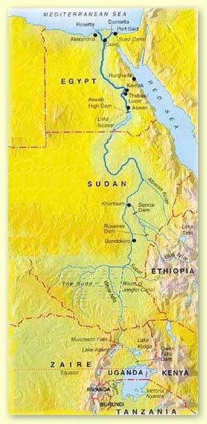
Three rivers flowed into the Nile from the south and thus served as its sources: the Blue Nile, the White Nile and the Arbara. Within the southern section between Aswan and Khartoum, land which was called Nubia, the River passes through formations of hard igneous rock, resulting in a series of rapids, or cataracts, which form a natural boundary to the south. Between the first and second cataracts lay Lower Nubia, and between the second and sixth cataracts lay upper Nubia.

Along most of its length through Egypt, the Nile has scoured a deep, wide gorge in the desert plateau. At Aswan North of the first cataract the Nile is deeper and its surface smoother. Downstream from Aswan the Nile flows northerly to Armant before taking a sharp bend, called the Qena. From Armant to Hu, the River extends about 180 kilometers and divides the narrow southern valley from the wider northern valley.

Southern Egypt, thus being upstream, is called Upper Egypt, and northern Egypt, being downstream and the Delta, is called Lower Egypt. In addition to the Valley and the Delta, the Nile also divided Egypt into the Eastern and Western Deserts.

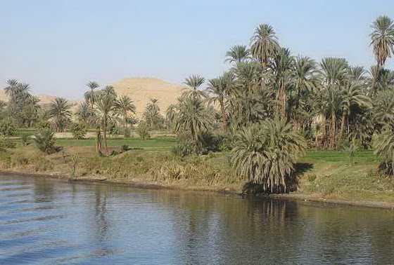
The Nile Just South of AswanThe Nile Valley is a canyon running 660 miles long with a floodplain occupying 4,250 square miles. The Delta spans some 8,500 square miles and is fringed in its coastal regions by lagoons, wetlands, lakes and sand dunes.

The Delta represented 63 percent of the inhabited area of Egypt, extending about 200 kilometers from south to north and roughly 400 kilometers from east to west. While today the Nile flows through the Delta in only two principal branches, the Damietta and the Rosetta, in ancient times there were three principal channels, known as the water of Pre, the water of Ptah and the water of Amun. In classical or Graeco-Roman times, these were called the Pelusiac, the Sebennytic, and the Canopic branches. There were additionally subsidiary branches or artificially cut channels.

The most dominant features of the Delta as the sandy mounds of clay and silt that appear as islands rising 1-12 meters above the surrounding area. Since these mounds would not be submerged by the inundation, they were ideal sites for Predynastic and Early Dynastic A modern sailboat on the Nile, with a not so unusual sail settlements, and indeed evidence of human habitation have been found. Perhaps these mounds rising above the water table inspired the ancient belief of creation as having begun on a mound of earth that emerged from the primordial waters of Nun (Pyramid Text 600).


The Largest Volcano on Earth - Mauna Loa (Hawaii)

Mauna Loa is the largest volcano on Earth in terms of volume and area covered and one of five volcanoes that form the Island of Hawaii in the U.S. state of Hawaii in the Pacific Ocean. It is an active shield volcano, with a volume estimated at approximately 18,000 cubic miles (75,000 km3), although its peak is about 120 feet (37 m) lower than that of its neighbor, Mauna Kea. The Hawaiian name "Mauna Loa" means "Long Mountain". Lava eruptions from Mauna Loa are silica-poor, thus very fluid: and as a result eruptions tend to be non-explosive and the volcano has relatively shallow slopes.


Angel Falls - The World's Highest Waterfall

Angel Falls or Kerepakupai merú (which means "waterfall of the deepest place", in Pemon language, or: "Parakupa-vena", which means "the fall from the highest point"; Spanish: Salto Ángel) is the world's highest waterfall, with a height of 979 m (3,212 ft) and a plunge of 807 m (2,647 ft). The waterfall drops over the edge of the Auyantepui mountain in the Canaima National Park (Spanish: Parque Nacional Canaima), a UNESCO World Heritage site in the Gran Sabana region of Bolívar State, Venezuela.

The height of the falls is so great that before getting anywhere near the ground, the water is atomized by the strong winds and turned into mist. The mist can be felt a mile away. The base of the falls feeds into the Kerep River (alternatively known as the Río Gauya), which flows into the Churun River, a tributary of the Carrao River.

The height figure 3,212 feet (979 m) mostly consists of the main plunge but also includes about 0.25 miles (400 m) of shallowly sloped cascades and rapids below the drop and a 100-foot (30 m) high plunge downstream of the talus rapids. While the main plunge is undoubtedly the highest single drop in the world, including the lower cascades somewhat stretches the criteria for the measurement of waterfalls. Some other waterfalls, such as Yosemite Falls in North America, also include intermediary cascades in their height figures, but, in the case of Yosemite Falls, the middle cascades are much steeper and have less run than those of Angel Falls.

In the indigenous Pemon language Kerepakupai merú means 'waterfall of the deepest place'. The falls are sometimes referred to as Churún-merú, an error, since that name corresponds to another waterfall in the Canaima National Park. Churún in the Pemon language means "thunder".


World’s Largest Snow Drawing


world’s largest snow drawing logo
These odd circles may look like messages from aliens or the humorous graffiti of penguins, but it’s actually the ephemeral snow and ice art of earth artist Jim Denevan, best known for his temporary beach masterpieces. The snow circles are somewhat of a departure from Denevan’s usual medium, but he’s no stranger to large-scale natural art. This nine-square-mile snow drawing currently holds the record as the world’s largest snow drawing; the record before that belonged to a sand drawing created in the Nevada desert by Denevan.
world’s largest snow drawing 01

Top 10 Most Dangerous Waves in the World


teahupoo1
With super advanced equipment, tow-in access, and internet swell tracking, a growing number of surfers are getting rides on incredibly powerful waves.
What makes a wave dangerous? Is sheer size an accurate indicator for how hazardous a surf spot is? Read on for our roundup of the top ten most dangerous waves in the world.


1. Cyclops (remote south coast Western Australia)
cyclops

World’s Largest Cave: The Son Doong (Found in Vietnam)


largest-vietnam-cave
A massive cave recently uncovered in a remote Vietnamese jungle is the largest single cave passage yet found, a new survey shows.
At 262-by-262 feet (80-by-80 meters) in most places, the Son Doong cave beats out the previous world-record holder, Deer Cave in the Malaysian section of the island of Borneo.
Deer Cave is no less than 300-by-300 feet (91-by-91 meters), but it's only about a mile (1.6 kilometers) long.
By contrast, explorers walked 2.8 miles (4.5 kilometers) into Son Doong, in Phong Nha-Ke Bang National Park, before being blocked by seasonal floodwaters—and they think that the passage is even longer.
In addition, for a couple of miles Son Doong reaches more than 460-by-460 feet (140-by-140 meters), said Adam Spillane, a member of the British Cave Research Association expedition that explored the massive cavern.
Spillane was in the first of two groups to enter the cave. His team followed the passage as far as a 46-foot-high (14-meter-high) wall.
"The second team that went in got flooded out," he said. "We're going back next year to climb that wall and explore the cave further."
largest-vietnam-cave 02

‘Supermoon’ Phenomenon: The Largest Full Moon In More Than 18 Years


supermoon03
The largest full moon in more than 18 years – a so-called "supermoon" – did not disappoint eager skywatchers around the world Saturday when it rose, big and bright, into Earth's night sky.
The full moon of March was 221,565 miles (356,575 kilometers) on Saturday, March 19 just 50 minutes after it hit its full phase, making it the biggest and brightest full moon since 1993. The "supermoon" phenomenon occurred because the moon was in its full phase and just 50 minutes past perigee – the point of its orbit that brings it closer to Earth. (source: space.com)
Did you miss it? No problem. Taken mostly from Flickr photographers from all around the world, here are ten of the best supermoon photos we've seen.
supermoon01

The Mysterious Nazca Lines (10 amazing pics)


Nazca_monkey
The Nazca Lines are a series of ancient geoglyphs located in the Nazca Desert in southern Peru. They were designated a UNESCO World Heritage Site in 1994. The high, arid plateau stretches more than 80 kilometres (50 mi) between the towns of Nazca and Palpa on the Pampas de Jumana about 400 km south of Lima. Although some local geoglyphs resemble Paracas motifs, scholars believe the Nazca Lines were created by the Nazca culture between 400 and 650 CE. The hundreds of individual figures range in complexity from simple lines to stylized hummingbirds, spiders, monkeys, fish, sharks, orcas, llamas, and lizards.
The lines are shallow designs made in the ground by removing the ubiquitous reddish pebbles and uncovering the whitish ground beneath. Hundreds are simple lines or geometric shapes; more than seventy are designs of animal, bird, fish or human figures. The largest figures are over 200 metres (660 ft) across. Scholars differ in interpreting the purpose of the designs, but they generally ascribe religious significance to them.
The geometric ones could indicate the flow of water or be connected to rituals to summon water. The spiders, birds, and plants could be fertility symbols. Other possible explanations include: irrigation schemes or giant astronomical calendars.
Mysterious Nazca Lines 01

The Most Famous And Scary Devil Tower


The-Most-Famous-And-Scary-Devil-Tower-01
One of the most famous and most mysterious places on our planet who adore travelers - a rock Devils Tower, located in the reserve in northeast Wyoming in the U.S..
Let's start with the fact that the Devils Tower or Devil's Tower - not only the name of this rock. With its other name is connected one of the Indian legend of the seven local girls who were walking in the woods when they threw a huge and ferocious bear. Girls long fled from the infuriated animal, but the bear would not leave. In desperation, the children climbed on a simple stone and prayed for the salvation of the Great Spirit.
The-Most-Famous-And-Scary-Devil-Tower-02

World’s Biggest Meteorite Craters


Meteor_resize
An impact crater forms when an asteroid or comet strikes another body such as an asteroid, planet, or moon at high speed. As Earth is so active geologically, most traces of impact craters have been erased by erosion and tectonic activity. Nevertheless, over one hundred seventy impact craters have been identified on Earth.
Here are some of the biggest Meteorite craters found on earth. I hope you will like it.

Barringer Crater, Arizona, US

Barringer Crater, Arizona, US

White Sands National Monument: The World's Largest Gypsum Dune Field


White_Sands_National_Monument_01
Located at the northern end of the Chihuahuan Desert of Southern New Mexico, lies the amazing national treasure known as the White Sands National Monument. Within this national monument you will find the largest concentration of white pristine gypsum sand in the world.
This almost snow-like-sand is produced by the Tularosa Basin. The basin was formed by the collapse of a dome made up of the gypsum sand. The collapse occurred about ten million years ago and what remains of the sides of the original dome are what we now call the San Andreas and Sacramento Mountain ranges.

White_Sands_National_Monument_02

Top 5 Most Amazing Caves of our World


5. Cave of Crystals (Mexico): world’s largest known natural crystals

Known as “the Sistine Chapel of crystals,” Mexico’s Cueva de los Cristales (Cave of Crystals) contains some of the world’s largest known natural crystals—translucent beams of gypsum as long as 36 feet (11 meters). The cave is 950 feet (290 meters) underground. The Naica mining complex, which yields lead, zinc, copper, silver, and gold, zigzags nearly half a mile underground (760 meters). Deep inside Naica mountain, the Cave of Crystals is a horseshoe-shaped cavity in limestone rock about 30 feet (10 meters) wide and 90 feet (30 meters) long.
Volcanic activity that began about 26 million years ago created Naica mountain and filled it with high-temperature anhydrite gypsum. When magma underneath the mountain cooled and the temperature dropped, the anhydrite began to dissolve. The anhydrite slowly enriched the waters with sulfate and calcium molecules, which for millions of years have been deposited in the caves in the form of huge selenite gypsum crystals.
4. Majlis al Jinn Cave (Oman): world’s second largest cave chamber

10 Most Exotic Waterfalls in the World


Waterfalls are always something amazing to look at. Here we are not talking big numbers but the most exotic waterfalls. Some of them are hidden deep inside thick forrest and you may have to track a couple of miles to reach but at the end the scenry and serenity that they will provide you is absolutely devine.

Here we have compiled a list of some of the most exotic waterfall around the world. Do let us know in comment section if you know any of the waterfalls that we has missed out.
Blaenrhondda Waterfall
Resting at the end of the Ronda river in Wales, this waterfall is miracle in itself. Photographers and nature lovers from around the world love to take a look at the wild gushes of water.
Burney Waterfalls
Burney waterfalls

10 Most Beautiful Lake Destinations


Every vacation, hike or adventure has its best part around a lake where you camp and bonfire at night. Nature decorates water perfectly with the scenic beauty around it, some of which really stand out.
Here we have compiled a list of some of the most beautiful lake destinations around the world. We hope you will like it.
Lake Tahoe
Lake Tahoe, North-America
Sitting in the heart of the Sierra Nevada range, this placid lake with its clear blue water is ideal for camping. You can just sit by the water and un wind after the daily stress of your life
Lake Derwent
lake-derwent